Well the 2nd edition is being put up on the site. The 1st edition was taken down due to size of photo's and service quality in some areas making it near impossible to put up any photo's. Hopefully I have found a way around this to put some text to the photographs while we have been having a break in Broome. I have gone through some of our 2500 photo's taken so far and selected 1021 to start the blog due to the requests for as many photo's as possible from our friends. I am in Coral bay and I think I should have the blog up to date by the the we leave tomorrow 16/10/12.
Our trip was suppose to be a quick trip to Perth and Mandurah in WA to see family and friends as we were unable to make our way across to WA earlier in the year to attend two weddings due to my health and a decision to sell our house and make a sea change.
With Helen finishing work in April and making the sea change to Hervey Bay in May we set about looking at options on how to get across to Perth. I officially finished work on July 2nd and we left our new home on July 19. A few different routes were discussed and it wasn't long before our quick trip across the black top escalated to a full around Australia holiday with a tentative time frame of 4 months being back home around end of October early November. As we currently sit in Exmouth (11 October) I guess we won't be home by the end of October or early November.
The options were always centred around starting our main trip from Charleville after Oliver had his 1st birthday which we were not going to miss.
With Rascals help in determining a route it wasn't long before we had a tentative route. This has changed many times along the trip and we both like the freedom to be able to change our plans on the run.
Rascal looking over the maps in our lounge room in Hervey Bay.
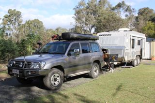
Part of my time before we left was involved with doing a major service on the van with all the wheels off to get in and do the brakes and wheel bearings and have a really good look over the van before we hit the rough stuff that was going to come. I also did some work on the car making Rascal a special seating so he had access to the windows and views all round without having to be climbing on the interior of the car. As the trip unfolds you will be aware that I didn't look hard enough on the car. New stone guards were made and I had arranged to have a new exhaust fitted at Beaudesert and an engine chip installed in Toowoomba.
Ready to head off from Belinda and Scotts at Cedar Grove.
We spent a few days in Toowoomba lodging at Gary and Annie's farm at East Greenmount.
Finally on our way to Charleville, morning tea break at Jondaryan.
First night on the road we stayed at the Neil Turner Weir at Mitchell.
Rascal was cold and still wearing his coat that we had bought him in Goomeri a few weeks earlier.
The next few photo's are the weir the next morning and our camp spot.
While in Charleville we stayed at the Baillie Bear caravan park which was just down the road from Tim and Rana's new house.
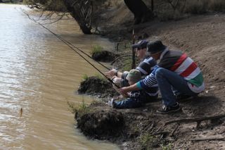
About time to put a rod in the young blokes hand.
Mum, they were trying to make me fish or something like that.
Look mum, I don't like them yet.
Oliver wanted too get up in the tree, honest.
See, he even got his dad to take him out on one.
Mum is dad going to catch a fish or is he going to be like Pa.
This is a better place to chill out.
Always have a standby in case the fishing doesn't work out.
Morning tea stop just outside Quilpie.
Stopped for lunch at Kyabra Creek waterholes near Thylungra.
Set up camp for a few days on the bank of Cooper Creek about 10km out of Windorah.
Pelicans feeding on the Cooper.
Helen looking at the little channel which flowed behind our caravan.
Rascal decided the water was too cold to go any deeper
Helen resting with her iPad
Sun setting on our camp spot
Helen and Rascal making their way back to the van
Sitting round the fire once tea was finished
Solar power station at Windorah
Livestock, they keep you guessing until you get past them.
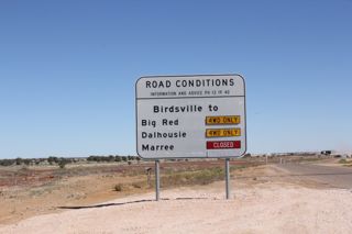
Rascal and I out for a walk near the Birdsville turn off.
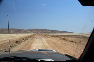
The start of the dirt
Emu's decided to check out what I was doing
letting the air out of the tires on the way to Birdville
last of the black top for a while
The road wasn't too bad for the most of it.
The next few shots are of a Wedge Tail eagle we disturbed while driving past his lunch.
nearly airborne
why don't I fly straight across the front of them.
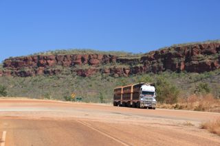
I pull up for these big rigs as the dust is impossible to see through when they go past.
Deon's Lookout near the Cordillo Downs turn off.
The old Betoota hotel, this is no longer on the main road.
Moonda Lake, normally dry but not this year.
Entrance to Birdsville
Camped on the banks of the Diamantina at the Windmill just out of town
Sturt Dessert Pea in the main street
The old Royal Hotel
The Burke and Wills tree near the river at Birdsville, as we changed our travel plans we decided to head north to the gulf. This means that we crossed Burke and Wills expedition route on several occasions.
The photo shot I guess everyone gets
crossing the Diamantina at the old river crossing
We were a couple of weeks early for the races,
so we decided to have a race ourselves and,
Helen made it to the finish post
The road out to Big Red
The alternate route to Big Red due to water still covering the normal track
an eagle nest
Helen standing where we would normally have come across
On the climb up Big Red
On top with a view west into the desert
A panoramic view looking North, East and South
Sunrise and Moon setting over Birdsville
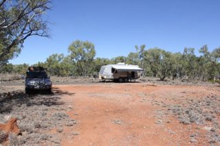
One of the three Wadi tree stands, one in the Simpson Desert, and another one we will pass near Bedourie.
Cacoory Ruins, the iron roof was removed during the WWII and never replaced.
Our camp spot at Bedourie, the thermal pool is just over in front of the car
Wadi trees north of Bedourie
Min Min exhibition in Boulia, didn't bother going in as Helen and I have seen the real thing.
The road out of Boulia to Mt Isa, this single lane sealed section is worse than all gravel because I got sick off people coming the other way and not bothering to slow down.
We decided not to go into Mt Isa and cut off at Dajarra and headed up through Duchess and on to Cloncurry.
The Duchess railway station, best structure in town.
A camel on the road north of Duchess.
Heading towards Mary Kathleen from Cloncurry
We headed into Mary Kathleen, looking for a camp site we decided it best to look on foot for somewhere to turn around before we go any further into the over burden heaps
Helen and Rascal going off to see if we can go up ahead, the answer was no.
Helen coming back down
Moved a couple of rocks and found a way round.
Helen at the base of the old crushing plant site
warning sign on the way up to the old mine pit
Our campsite on one of the roads in the old town site
relaxing getting a bed of coals to cook dinner on
Rascal did you drink too much radioactive water
Look what it has done to my hair (actually just gave him a bath)
A little lunch at the turn off towards Lake Julius after restocking in at Mt Isa
The Lake Julius / Kadjabi road
The road into Lake Julius
Lake Julius, we were up at the lookout, when a ranger came out. After a chat he told us we could camp down at the boat ramp as no one else was around.
All this to ourselves
A spot of fishing
Not what you expect to catch in the cabbie net. A freshwater flathead ?
crossing the Leichardt River on the way back out
As the road was very quiet, Helen decided to have a drive for a while
Rascal wasn't to concerned so it must have gone OK.
Nearly some road fresh kill
Leichardt River again
Leichardt River at Kadjabi
The Burke and Wills Roadhouse
Bang Bang Jump up rest area
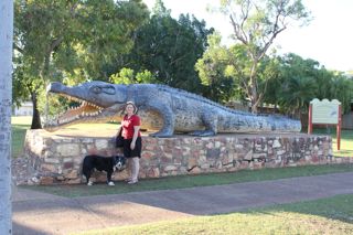
A statue of a replica of a croc that was caught up this way in the 1950's
The old Burns Philp building in Normanton
doing a spot of fishing at Karumba
Met the grandchildren at Karumba, they didn't know we were going to be there.
We took them down to the beach why Belinda and Scott set up the camper.
Heading out on the Savannah Way towards Leichardt Falls
The next few are of an eagle that was having a feed and almost became a hood ornament
Crossing the Leichardt River at the Leichardt Falls
Old pumping equipment near the base of the falls
Helen at the falls with our van in the background
not much going over at the moment
found a section that looked safe for Rascal to have a swim
next morning Rascal, having a photo shoot while he is clean
Albert River near Burketown, a novel use of the old bridge.
Burketown jetty
The boat ramp, guess someone slipped at some point.
Crossing the border into the Northern Territory
Some of the many crossing between Burketown and Borroloola
Lunch at Batten Creek
56 km to go to Lorella Springs turn off, it was just as we left here the turbo decided to let us know what the problem was as we were pulling out of the creek crossing.
Only another 29 km to go
This is private road, better than some of the main roads.
last gate
Fixing the car, the turbo had vibrated loose from the exhaust manifold. No wonder the car was a little down on power once we left Batten Creek. 3 nuts are better than none. Enough to get us to Darwin and do a bit of 4WD'ing at Lorella before we leave.
A swim in the hot spring after fixing the car.
Vibration
Can you see the crocodile in the water behind the boat
one of the hot water sources flowing out from the rock face.
algae in the stream flow
Helen soothing her feet
One of the many creek crossings
parked up for lunch at Rosie Creek
more bull dust
leaving the camping area at Lorella Springs
The mail box at Nathan River Station
Deciding if we will stay or not ? Towns River
Guess we did.
Fog on the river next morning looking upstream
looking downstream
Helen having a fish at Towns River
Guess this is close enough to the edge, use the rock bank to tie the annexe down.
Rascal keeping an eye on things.
All I seem to be able to catch is small cat fish
Morning tea stop
Lomarieum Lagoon behind the St Vidgeon ruins
One of the many camp sites along the Roper River near what is called Tomato Island.
The road to Roper Bar
Just another shot of the changing scenery
It would be interesting to find out why this is called the Queensland crossing when we are a long way into the NT.
Not much water in the rivers at some places
Heading in to Roper Bar, did a little too much 4WD'ing at Lorella and really hoping to get to Roper Store before we run out of fuel.
The next few shots are of the Roper Bar and crossing point to Ngukurr
These ones were taken from the boat ramp below the van park.
Our camp site in Katherine at the van park near the hot springs.
Washed the car now the van, the attendant was not impressed with the red slurry that was coming off. We had washed it at Towns River so it was better than it could have been.
clean for a little while
the "303" Bar at Adelaide River
Adelaide River War Cemetery
Darwin City beach
This was in the mall in the main centre of Darwin
Australian and Japanese Navy in port
Picked up Rascal from his day at the groomers
Doing an oil change at Vince Connoly crossing between Katherine and Timber Creek
Draining the old oil back into the container and keep it until we find a recycle centre.
next morning getting ready to head off
Don't forget to put me in the car
Morning tea at Victoria River roadhouse
Please mum can I have a biscuit
Wouldn't it be nice if the Bruce Highway was like this.
Another boab
Camp spot at the "Saddle"
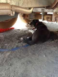
Rascal enjoys resting in the cool under the van in the dirt
I shouldn't sit here what if a car comes past in the next hour or two
on the way to Lake Argyle
This guy had come a long way and still had a long way to go
Rascal in his usual position
spillway channel
driving towards Lake Argyle
Ord River dam
canoists on the lake
Ord River
Letting Rascal have a swim to cool down in the spillway channel
Rascal just shook himself next to Helen
Our camp spot at Lake Argyle
Chilling out with Rascal
We acme up to the lookout to wait for the sunset
Helen talking to her dad on the sat phone
Durack Homestead _dark spots in the centre of the photo
Infinity pool in the caravan park
The rum distillery in Kununurra
Rascal had a hard day
Sunset from the lakeside caravan park Kununurra
Rascal on the lookout at Kununurra
The diversion dam at Kununurra
Rascal in his lookout pose again
It was very hot and a long way down, the water is said to be 300 feet deep in this water hole.
The water didn't even entice Rascal in for a swim
The new jetty at Wyndham, the tide was over 10 metres while we were here and had a hard time getting my fishing line to sink later that night on the incoming tide.
We decided to take a drive down to the Prison Boab tree down on the King River
The road across the salt flats
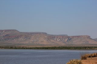
The north Cockburn range from the King River road
Helen getting lunch ready on the banks of the King River water holes
King River on the northern end of the Emma Gorge Station
Helen on Croc watch
Heading up to the look out at Wyndham

End of the bitumen at the entrance to EL Questro Station
One of the many 4WD drive tracks around ELQ heading up to one of the lookouts.
ELQ homestead, only around $1500 a night
Chamberlain River crossing
These shots are taken from Branco's lookout
ELQ homestead centre on the Chamberlain River
this one and next 2 photos make up the panorama shot below
If you look on the ledge you see a log, just in front of that on the next ledge is a crocodile
the road down
the way up to Explosion Gorge
Explosion Gorge North it got it's name due to early fishing techniques.
Explosion Gorge South
Explosion Gorge centre
the track out
ELQ homestead
entering the Chamberlain river crossing
part of the crossing heading back to camp
Hot spring in the campground
ELQ is very pet friendly as long as you abide by the rules. We could take Rascal everywhere except into the gorges,, this was not a problem and very easy to accommodate. When we went to the springs we left early found a very shaded position for the car and left Rascal for an hour with the windows down. In his usual guard dog duties he went to sleep and didn't hear us when we came back.
upper and lower pools
The spring waterfall
another soak coming out below the rocks
The trick is getting in before everyone else turned up, it was very peaceful with only 3 people up there originally, made the photo taking easier also.
Jackeroo's waterhole
on the way to EL Questro and Moonshine Gorges
We didn't go any further as it was getting too hot to leave Rascal so we just had a look around the start to the trails so we have an idea what to bring when we come back next time
I had to give him a cuddle for being a good boy
The track up to Saddleback ridge lookout
ELQ camp area is centre and this photo is the centre of the next one
Look at the next group of 8 photo's as a panorama going left to right 360 degrees. It was a pity so much smoke was in the air from the fires near Wyndham.
airstrip centre of shot
Pentecost river below lookout with road going out to ELQ lodge, Chamberlain gorge and river, Explosion gorge and Branco lookout
The lookout a ken while we were crossing the Pentecost at one of the many crossings within ELQ.
The Durack Boab Tree
fishing just below the ELQ homestead on the Chamberlain River
Another vier of Saddleback Ridge lookout from near the airstrip
campsite in ELQ, we were interviewed by C&MH magazine for the January magazine while we were here.
leaving ELQ after filling up with fuel
The ELQ private road to the GRR
the GRR on the way to Home Valley Station our next stop
Cockburn Range looking North
a view of some of the corrugations
SW face of the Cockburn Range
Approaching the Pentecost River crossing
Our taxpayer dollars being spent in a safe manner, 4 car loads of these thrill seekers crossed like this. Guess I would probably have done the same when I was young.
pulled up for a walk and to give Rascal a swim if we could find somewhere safe
going back so we could get some photo's as Helen wouldn't walk across. (something about croc's I think she said)
You enter HV station grounds once you cross the Pentecost River
Cockburn Range taken from near HV8 entrance
HV8 is the brand, why not HVS ? well we were told that HVS was to easily modified by cattle duffers so HV8 was adopted to stop this
our camp spot at Home Valley Station
We thought this was a big croc when we were looking at him
one of the locals said they called him Cedric and he lives in this section of Bindoola Creek and the Pentecost River
one eye on the croc, one on the fishing line, just a couple of cobbler (catfish)
join the next few slides together left to right
this is the slide of a 5 1/2 metre croc, the big black one in the earlier slides
yes that is someones foot prints going across, hope they weren't at the same time
you can just see another little croc up at the boat ramp
this was the little fella
The main entrance to Home Valley, our van is just up through the exit side.
another view of our campsite
a different view of a boat
sun setting on the Cockburn Ranges from the HV8 airfield
down at one of the many areas to get a nice view of the changing colours
We didn't stay dow here as it was only about 5 km drive down here
Bindoola Creek and Pentecost River junction
The rock bar that separates salt from fresh is just up the river at the next bend
Bindoola Creek, fishing spot the croc slide that I showed earlier is just next to where the car is parked
just mucking around with some camera settings
We decided to try our luck and go 4WDing and fishing up at the Salmond River Gorge, 11km in after leaving the GRR. This is as far as the driving track goes on foot from here.
I set up the fox wing for Helen and Rascal while I went down and did a spot of fishing down below
Cockburn ranges in the distance, nice place for a cup of coffee and a snack
didn't see any crocs but the Pentecost is only a few kilometres downstream
me down in the bush having a fish, plenty of small sooty grunters but nothing worth keeping
the next few shots are the track back to the GRR, it was about 11 km into the gorge and back out (22), the problem on the way out was that we had the turbo issue again which only became obvious after the car cooled down and we started to drive back out.
marker stones painted with white to direct you across this rock platform, trickier than it looks in the photo, sharp and deep drops
another dry crossing
the last dry creek crossing before the GRR on the way back from Salmond River Gorge
another one that doesn't look like much till you get into it and try and place your wheels in the right place so you don't crunch a panel or your diff.
also the first one in, guess it would stop some people going any further. I walked it and had a good look on the way in before we decided to go any further. You are a long way from any help out here if you get it wrong.
Heading back into Kununurra to get a part for the turbo (again), this is the section of road near the entrance to ELQ that is going to be asphalted.
fires on the way back into town
arrived at the Toyota dealer at 4.00 pm they closed at 4 but they were more than happy to assist.
heading back out after getting the turbo nut that I required, they only had one and as I told the salesman I don't need two so one will do. Fires were a little closer to the road on the way back.
time to head back on the GRR, Cockburn range in the distance
had a couple of roo's and some cattle come out on us, glad I have a decent set of driving lights
crossing the Pentecost again only about 15 km to go, the two illuminated dots in the distance are where we turned off this morning to head up to the Salmond River gorge which started this night drive in the first place.
The intersection of the Gibb River Road (right) and Kalumbaru Road (left)
The Gibb River, looked like a nice spot to pull up for the afternoon, this was taken from the road crossing that I let Rascal have a swim in. Not long after this when we were back at the van a croc appeared just behind the tree stump in the centre of the picture. it than came down and sat just of the bank near the van.
Sometimes you can be in the right place at the right time for a good photo, the road crossing is at the area of thick trees.
Helen enjoying a drink, while we were discussing what we would do with Rascal tonight due to the croc in the area, we decided to move on as it was too hot for Rascal to sleep inside. Little did we know all manner of disasters were under way. The fridge cracked a line into the compressor, so it was convert the car fridge(drinks fridge) to a freezer and see what we could salvage before we lost too much. All done we were on our way just as the sun was going down.
After going through a couple of creek crossing at night without knowing how deep until you get in and not able to find a suitable pull off area we eventually pulled up in a clearing on the side of the road, guess you can do that in the dark. Nowhere as pretty as our previous spot but no crocs either.
When you pull up last thing you want to see is white liquid on the floor of the van when you open the door ? the cartons of long life milk had rubbed together due to the vibrations and spilt most of the contents which had than run in to most of the awkward places to clean out. Luckily it didn't take very long to clean up, but made us re think some of our storage. The milk is know stored in one of the padded freezer bags that Helen had.
You can see some of the corrugations with sun at this angle.
We took this track into Barnett River Gorge, only 3 km took about 45 minutes to drive in
At the 2nd car parking area at the end of the formed track
a different type/shape of Boab tree
part of the track going out (which you can see in the slide below), we purchased a GRR book at the Mt Barnett Roadhouse which had information on this track and basically suggests leave your car at the first parking area that we had already passed and walk the last few kilometres in.
have no idea why they would suggest that
Pulled over to let the dust settle after a truck passed
Not all the road was bad, this section was very good
The rock feature on the right is suppose to look like Queen Victoria
Lennard River
Helen at the Lennard River crossing, we had lunch here
The end of the Gibb River Road
On the jetty at Derby watching sunset and than had a feed of fish and chips
The Prison Boab tree at Derby
Derby Jetty at high tide, the tides were in the vicinity of 10 metres variation the few days we were here.
Another eagle on the way into Broome
Cable Beach southern end, I don't normally like driving on beaches but once we turned down the track you had to keep going.
You can only drive along for about 500 metres, but it was somewhere nice for Rascal to have a run.
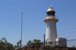
Gantheaume Point, lighthouse and dinosaur foot prints in the rocks if you get the right tides
Walking out to th point
looking towards Cable Beach
Looking south
Rascal and Helen went for a walk along th beach and rocks while I was fishing
It's a long jetty and we had a few days so I tried several spots along it to fish (should have gone to the fish shop)
The old and the new, a pearl lugger doing a tour and a rig resupply vessel doing a different type of tour
the next three slides are taken from the grassy knoll at Town Beach (left to right)
Roebuck Bay
Town Beach and the deep water jetty in the distance
You think that you could have too many sunsets, but everyone is different and has its own spell of magic to draw you n to watch
Helen enjoying herself at the park area near Cable Beach
Helen watching the camels going back after the sunset walk along Cable Beach
Willi Creek pearl farm
Helen standing at one of the many camp sites available at Quondong Point
Cape Leveque Island
West beach

heading down to east beach
They didn't mention the oyster covered rocks in the shore break that my toes found.
Cape Leveque Island
Looking south from the lookout at Cape Leveque
Heading into Cygnet Bay
next few slides are taken from the lookout at Cygnet Bay view left to right
Cygnet Bay Pearl Farm, I sat outside having a coffee while Helen went on a Pearl valuation tour. This was constructed in the old pearling masters quarters.
The coffee was better me thinks
All smiles but no pearls
heading back into Middle Lagoon after our day up at Cape Leveque
getting ready for sunset at Emeriau Point
Middle Lagoon after glow when we got back to our van
Pearl shell alter in Beagle Bay church
Any body notice anything missing after coming back down the Cape Leveque Road (hint, van is still on the back)
Rascal having a bath at Cable beach
Broome Tarangau van park
On the way into Barn Hill, wish all the dirt roads were as good as this one was.
Our camp site at Barn Hill.
The Pinnacles at Barn Hill station
Walking along the beach
Sunset from our own private deck behind the van
Sandfire Roadhouse on the way to De Grey River
De Grey River
The road bridge crossing the De Grey River
Port Headland, no places to camp here with Rascal so we had morning tea at the lookout, a quick look around the town centre a few supplies and off.
After leaving Port Headland we headed for Roebourne and Point Samson, not really much at Point Samson except a very expensive caravan park but it is what is around that is worth the stay. This slide and the next were taken at Point Walcott on the other side of the peninsula at the side of the Cape Lambert rail head and port facility.
These were taken from Readers Head lookout Cossack
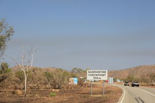
The old quarantine station
Rascal in his lookout pose again
The tidal outflow at the road bridge in to Point Samson
The quarantine station and river mouth at the head of the old Cossack port
Sunset at Readers Head Cossack waiting for the moon to rise so we can hopefully see the stairway to the moon.
The next two slides are the river heading up to the old port of Cossack, this is a very interesting little place with a museum and walking trail of the old town. Met up with Russ and Sue who currently manage the B&B and kiosk at Cossack and also are members of the KOG
full moon rising over the tidal flats
The double image, I think is a combination of the filters and my hand on the shutter even though I had the camera on a tripod
Don't know how this happened but I like it.
After leaving Point Samson we headed for Cleaverville a camping area on the coast, we arrived the day after the season finished and virtually had the pick of any spot we wanted. Just behind the van is a little cove with a nice swimming beach at high tide and a reef at low tide.
We walked up to the top of a hill to get this shot of our van and the beach behind at low tide, the road on the left goes around to the boat ramp on the creek
Sun setting over the Burrup Peninsula, almost directly over the NW Gas Shelf site, at night we could see the flare off pipes
Helen enjoying the sunset
I take the photo's of the sunrise so Helen can get to see what it looks like
Some birds decided to see who was inside looking through our skylight
This is our beach
The sun was very bright so Rascal tried on my hat and he actually liked it.
Final sunset at Cleaverville
Luckily we have friends in Karratha who allowed us to park in the yard and looked after Rascal for us while we went driving around Dampier and Karratha.
Red Dog statue at Dampier
Port area at Dampier
The original flame at the Woodside North West Shelf Gas Project
Woodside taken from near the jump up on the Burrup Peninsula
We were lucky enough to be able to go up this gorge near Hearson Cove, it is not advertised but has aboriginal rock carvings, we were told by Ian and Sue you have to let your eyes adjust than they start to become easier to see.
The woodside flare looks like it is just coming out the top of the ridge.
Dampier Salt
Ian and Sue's accomodation on the right the flat next door was vacant so we parked up on the driveway.
Leaving Ian and Sues at Karratha we headed for 40 mile beach for a few days.
Like Cleaverville the season had finished so we could choose our own spot
A view up the beach at near high tide, the beach consists of a limestone ledge which drops off to a lower beach
Not far to walk down to the water
Just had to get the old girl up the track to the top of the sand dune otherwise much backing and turning would have been required.
Salt heap at Onslow
The Old Onslow township, only two old buildings are still standing with most structures being relocated to new Onslow. This is the old Police building
This is the old cell block, with exercise yard in the front large room. Complete with centre ring to chain the prisoners (guess it gives a new meaning to lifting weights)
Heading to Coral Bay