Our Darwin holiday was to be our last as a working couple. Not long after returning home my health deteriorated and we decided to call it a day and retire. Here are a couple of photo's of what you can do in 5 weeks.
Our holiday started in Toowoomba on July 22nd and we arrived home on Sunday 28th August and I started work on the 29th.
We took a few days getting to Longreach, spending nights at Chinchilla weir, Barcoo River, and Crawford Creek on the northern side of Longreach.


On the way to the jump up outside Winton visiting the Age of Dinosaurs.


Bitter Springs near Mataranka, this was a lovely swimming area. Crystal clear water and natural surrounds.


Photo opportunity with our friends alongside one of the bigger termite mounds.


We did have concerns when walking the crossings.

Heading north to Berry Springs from Litchfield NP.

Waiting at Berry Springs for the rest of the group.

A relaxing swim at Berry Springs.

The Top End, finally made it to Darwin.

We decided to have dinner on the wharf and watch the sunset.

After leaving Darwin, we headed to Shady Camp located on the Mary River. They say this area has the largest population of large saltwater crocs in the Top End. We were not disappointed.

This was only a little one, the big ones came out at night when you walked down to the Barage on the tide change.


A little croc and wallaby sharing the sunlight.

We were feeding the Kites pieces of steak, they would sit in the tree and wait for us to throw a piece in the air and they would take off and catch it.


Water front at Point Stuart boat ramp.

After Shady Camp we moved on to Ubir at the border store and went up to watch the sunset.

We went for one of the designated walks in the area, this may give you an idea of why you have to be careful, this croc was a long way from the main river and had obviously made this water hole his own.

Some of the rock art on the walk.

One of the locals on the upstream side of the causeway.

These cockatoos started screeching just above our van, eventually four of them joined in, the only thing we could think of was that something had gone into the nest.

The advantage of a good 4WD getting into these areas. This is the billabong that a tourist was taken by a croc a few years ago. The main area of the billabong the water was actually tannum black, you would have to be stupid to consider swimming here.

We went for a drive up to Nourlangie Rock. Well worth the walk around this area.

We had to cross Jim Jim Creek on our way up to Twin Falls. 700 mm deep.

Two ways to Twin Falls, walk to the top or take a boat trip to the base. Glen, Debbie and I walked to the top. Helen and the others went in the boat.

View of Twin Falls walking up to the boat.

View from the top.

One of the advantages of walking to the top, Helen said you are not allowed to swim in the lower area below the falls.

After leaving Twin Falls we headed across to Jim Jim Falls, the walk up is relatively easy until the last few hundred metres than you get an idea of why they put a sign at the start saying rocky track. The next few photo's are right at the end of the gorge behind the trees.


After loosing the girls in the rocks Glen and I went for a swim in the lower pool and made our way up to the main plunge pool. The water temperature difference between both pools is substantial. The girls finally caught up and we talked them into swimming back to the beach in the lower pool.

Sunrise on the Yellow Waters wilderness cruise, the amount and variety of birdlife was excellent.

One of my favourite shots for the holidays.

A basking croc on one of the reed beds.

One of the many water flowers.

After leaving Yellow Waters we headed down to Gunlom, this is a section of the rock pools with sandy bottoms above the main water fall.

The smaller waterfall is fed from another small rocky gorge which is fed by another waterfall fed from a nice creek and billabong on the escarpment.

Camped out on the way across to Booralloola with Glen and Deb and Alan and Rhonda.

One of the many crossings coming down the SavannahWay.

A familiar site on the Savannah Way, red dust over everything but luckily not inside the van.

Not a sight you want to see, Greg and Judy were in front of by a couple of hours and came across this incident. No major injuries to the people luckily.

Driving into the night after we left Greg and Judy at the accident site we came across this old quarry hidden in the bush just off the road. Greg and Judy caught up later that night. This photo was taken next morning.

Made it to Hells Gate for morning tea.

The northern entrance to Bowthorn Station and Kingfisher camp.

Rhonda's birthday at KFC called for a scone.


Leaving KFC and this part of Bowthorn Station.

This is where the water enters Lawn Hill gorge at the top of the third gorge which we paddled up to and had a swim after parking our kayaks.


Heading down the second gorge on the way back.

Adels Grove airfield on the left side of the photo this was taken from the Constance Range walk at Lawn Hill.

We came across this little fella on the way back to our campsite.

Hand feeding the fish at the back of our campsite.

After leaving Adels Grove we headed down to Gregory River and set up camp. The trip was getting to an end as we had to get back to work.

Castle Hill Townsville, we left Glen and Deb at Charters Towers and decided to head south via the coast as we had a few more days and were going to surprise our grandchildren who were camping at 1770.

On the way south we called in to Schute Harbour for lunch.

The heavens were about to open so we headed into Camilla Beach for the night and woke up next morning to these beautiful views.
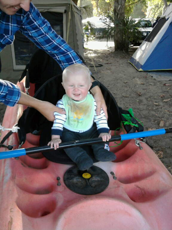
Fletcher learning how to use Glens kayak at 1770.

Last day camped at Imbil with Glen and Deb.
This is the end of this trip a great time nearly 10,000km in 5 weeks, my favourite spot was Gunlom Falls, Kakadu NT. I took nearly 2000 photo's this is a sample of our holiday. Hope you enjoy.